Aerial Imaging Market Report Scope & Overview:
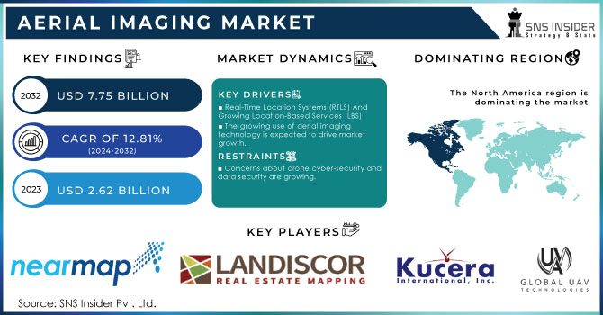
The Aerial Imaging Market Size was valued at USD 2.62 billion in 2023 and is expected to reach USD 7.75 billion by 2032 with a growing CAGR of 12.81% over the forecast period 2024-2032.
Growing application areas are expected to provide new growth opportunities for the aerial imaging market. The technology offers an efficient solution for a variety of purposes, including route design, planning, volume calculation, map renovations, and so on. Aerial imaging is used for a variety of purposes such as construction and development, geo spatial technology, disaster management, research and conservation, and so on.
Over the forecast period, increasing technological advancements in camera systems and aerial platforms are expected to drive market growth. Furthermore, increased awareness of the benefits of this technology is expected to boost market demand. Growing location-based services are expected to drive growth in the aerial imaging market over the forecast period.
To get more information on Aerial Imaging Market - Request Free Sample Report
The process of capturing images of ground surfaces using cameras attached to vehicles such as helicopters, parachutes, aircraft, kites, unmanned aerial vehicles, balloons, vehicle-mounted poles, and airships is known as aerial imaging. Risk mitigation, resource planning, mapping, research and excavation, security and surveillance, urban planning, engineering, farming management, tourism, and other applications benefit from aerial imaging. Aerial imagery services have grown in popularity due to their numerous applications, which include photo gram-metric surveys, topographic map development, environmental studies, surveillance, and others. Increased application areas across various verticals, including agriculture, forestry, energy & resources, and civil engineering, are expected to drive market growth in the coming years.
MARKET DYNAMICS:
KEY DRIVERS:
-
Real-Time Location Systems (RTLS) And Growing Location-Based Services (LBS)
-
The growing use of aerial imaging technology is expected to drive market growth.
RESTRAINTS:
-
Concerns about drone cyber-security and data security are growing.
-
Image data collection inaccuracy
CHALLENGES:
OPPORTUNITIES:
-
The Agriculture Sector Is Increasingly Adopting Aerial Imaging Solutions
-
Increased use of augmented reality with drones
THE IMPACT OF COVID-19
The COVID-19 outbreak had a global impact on the aerial imaging industry. The COVID-19 pandemic has slowed new product deliveries for the majority of large drone and UAV manufacturers due to supply chain disruption. The pandemic has also had an impact on revenue streams allocated to R&D and the adoption of new technologies in the aerial imaging sector. Throughout 2020 and mid-2021, challenges such as manufacturing difficulties and low demand for new drones and UAVs in the face of stringent lockdown measures were observed. However, post-pandemic demand for aerial imaging is expected to increase significantly due to the growing application of aerial imagery and analytics in a variety of end-use verticals.
The aerial imaging market operates in a variety of industries including government, power, military and defense, agriculture, trade and civil engineering, etc. Government is expected to be an integral part of end-of-life spending during the forecast period. The public sector uses this technology for a variety of purposes such as city planning, national security, energy management, and environmental studies, etc. In addition, agricultural and forestry applications and trade are also expected to grow significantly during the forecast period.
A few agricultural applications that include testing and planning of fertilizers and pesticides, soil sampling, and creating controlled areas, etc. In commercial applications, aerial imaging is used to monitor the progress of creation, advertising, and promotion. In addition, increasing the use of aerial imaging in the construction and management of natural resources is expected to favor market growth in the forecast period. Road planning, land use calculations, and proven groundwork references are just a few of the features used by civil engineering. The use of the energy system includes mining operations and goods etc. The aerial imaging market is divided into four sections: application, end user, platform, and region. Geospatial mapping, disaster management, energy and resource management, surveillance and monitoring, urban planning, and other applications comprise the global market.
Furthermore, factors such as a growth in demand for aerial imaging in catastrophe risk reduction and prevention, an increase in demand for various commercial applications, and the usage of aerial imaging technologies all contribute to an increase in demand. in the establishment of 5G infrastructure are expected to supplement aerial imaging market growth. However, stringent government regulations concerning national security, inaccuracy in image data collection, and rising concerns about cyber-security data security in relation to drones are expected to stymie market growth. Advanced motion and temperature sensors in cameras, 3D mapping software, unmanned aerial vehicles, and other technological advancements have created numerous opportunities for market growth.
KEY MARKET SEGMENTATION
By End User
-
Government
-
Military and Defense
-
Energy
-
Agriculture and Forestry
-
Civil Engineering
-
Media and Entertainment
-
Commercial
By Platform
-
Fixed Wing Aircraft
-
Helicopter
-
UAV and Drone
-
Others
By Application
-
Geo spatial Mapping
-
Disaster Management
-
Energy and Resource Management
-
Surveillance and Monitoring
-
Urban Planning
-
Others
REGIONAL ANALYSIS
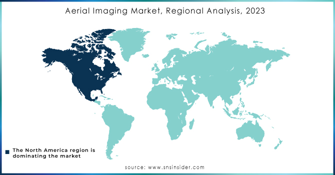
The aerial imaging market is dominated by North America. Because of the presence of prominent players such as Eagle View Technologies Inc., Near map Limited, Digital Aerial Solutions, LLC, and SZ DJI Technology Co., Ltd., the region's dominance in the aerial imaging market is expected to continue throughout the forecast period. Furthermore, the region is home to some of the market's major players, including Eagle View Technologies Inc., Drone Deploy, Inc., Cooper Aerial Surveys Co., and Digital Aerial Solutions, LLC. Furthermore, the increasing adoption of aerial imaging solutions by organization at both the public and private levels is expected to drive growth in the North American aerial imaging market during the study period.
During the forecast period, the APAC aerial imaging market is expected to grow at a rapid pace. Increased adoption of aerial imaging solutions, primarily in the energy, agriculture, and land surveying sectors, is expected to drive market growth in countries such as India and China. Asia-Pacific represents a lucrative investment opportunity for companies providing aerial imaging solutions. Furthermore, the region's major energy companies have bolstered their optimization plans with innovative digital solutions, which is expected to bode well for the region's growth of aerial imaging solutions.
Europe held a sizable share of the aerial imaging market. The growing demand for geographic data generated by UAVs, aerial surveys, and aerial imagery propels the aerial imaging market in European countries such as the Netherlands and the United Kingdom. Furthermore, the region's countries have increased their spending on geographic data and aerial surveys, primarily for oil and gas exploration, coastal navigation, and disaster management, which is expected to fuel regional market growth.
Need any customization research on Aerial Imaging Market - Enquiry Now
REGIONAL COVERAGE:
-
North America
-
USA
-
Canada
-
Mexico
-
-
Europe
-
Germany
-
UK
-
France
-
Italy
-
Spain
-
The Netherlands
-
Rest of Europe
-
-
Asia-Pacific
-
Japan
-
south Korea
-
China
-
India
-
Australia
-
Rest of Asia-Pacific
-
-
The Middle East & Africa
-
Israel
-
UAE
-
South Africa
-
Rest of Middle East & Africa
-
-
Latin America
-
Brazil
-
Argentina
-
Rest of Latin America
-
KEY PLAYERS
The Major Players are Cooper Aerial Surveys Co., Digital Aerial Solutions (DAS), LLC, Global UAV Technologies Ltd, Kucera International, Landiscor, Nearmap Ltd., EagleView Technologies, Inc., Fugro N.V., Aerial Imaging Productions, LLC, Blom Norway AS, and other players.
| Report Attributes | Details |
|---|---|
| Market Size in 2023 | US$ 2.62 Billion |
| Market Size by 2032 | US$ 7.75 Billion |
| CAGR | CAGR of 12.81% From 2024 to 2032 |
| Base Year | 2023 |
| Forecast Period | 2024-2032 |
| Historical Data | 2020-2022 |
| Report Scope & Coverage | Market Size, Segments Analysis, Competitive Landscape, Regional Analysis, DROC & SWOT Analysis, Forecast Outlook |
| Key Segments | • By End User (Government, Military and Defense, Energy, Agriculture and Forestry, Civil Engineering, Media and Entertainment, and Commercial) • By Platform (Fixed Wing Aircraft, Helicopter, UAV and Drone and Others) • By Application (Geospatial Mapping, Disaster Management, Energy and Resource Management, Surveillance and Monitoring, Urban Planning and Others) |
| Regional Analysis/Coverage | North America (USA, Canada, Mexico), Europe (Germany, UK, France, Italy, Spain, Netherlands, Rest of Europe), Asia-Pacific (Japan, South Korea, China, India, Australia, Rest of Asia-Pacific), The Middle East & Africa (Israel, UAE, South Africa, Rest of Middle East & Africa), Latin America (Brazil, Argentina, Rest of Latin America) |
| Company Profiles | Cooper Aerial Surveys Co., Digital Aerial Solutions (DAS), LLC, Global UAV Technologies Ltd, Kucera International, Landiscor, Nearmap Ltd., EagleView Technologies, Inc., Fugro N.V., Aerial Imaging Productions, LLC, Blom Norway AS, and other players. |
| DRIVERS | • Real-Time Location Systems (RTLS) And Growing Location-Based Services (LBS) • The growing use of aerial imaging technology is expected to drive market growth. |
| RESTRAINTS | • Concerns about drone cyber-security and data security are growing. • Image data collection inaccuracy |
Frequently Asked Questions
Cooper Aerial Surveys Co., Digital Aerial Solutions (DAS), LLC, Global UAV Technologies Ltd, Kucera International, Landiscor, Nearmap Ltd., EagleView Technologies, Inc., Fugro N.V., Aerial Imaging Productions, LLC, Blom Norway AS
The Agriculture Sector Is Increasingly Adopting Aerial Imaging Solutions and Increased use of augmented reality with drones
Real-Time Location Systems (RTLS) And Growing Location-Based Services (LBS) The growing use of aerial imaging technology is expected to drive market growth.
The COVID-19 outbreak had a global impact on the aerial imaging industry. The COVID-19 pandemic has slowed new product deliveries for the majority of large drone and UAV manufacturers due to supply chain disruption.
Manufacturers/Service provider, Consultant, Association, Research institute, private and universities libraries, Suppliers and Distributors of the product.
Get in Touch
