Geospatial Solutions Market Report Scope & Overview:
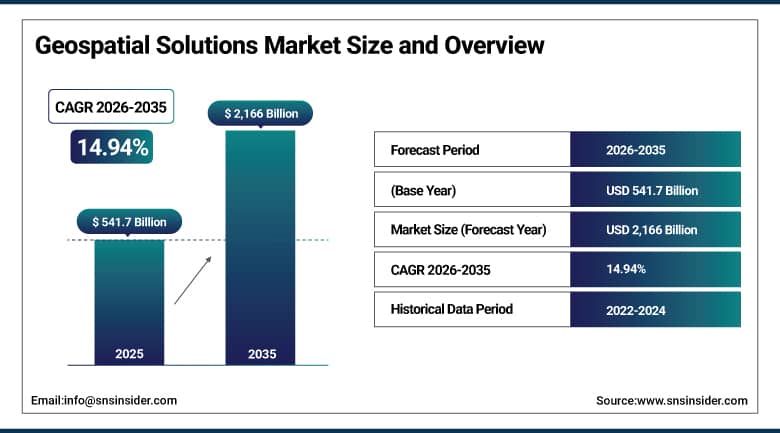
Geospatial Solutions Market was valued at USD 541.7 billion in 2025 and is expected to reach USD 2,166 billion by 2035, growing at a CAGR of 14.94% from 2026-2035.
Geospatial solutions have experienced growth because there is an increase in the need for location-based analysis in sectors such as urban planning, agriculture, defense, and transportation. The use of GIS, satellites, and drone technologies ensures that data is accurate. Additionally, the adoption of smart cities and IoT systems promotes market growth.
The U.S. federal government invested approximately USD 1.2 billion in geospatial data infrastructure in 2023 according to USGS data analytics program assessments. The EU's Copernicus program established a 15% increase in satellite imagery and data budget to ensure comprehensive environmental and climate monitoring coverage across European territories.
Geospatial Solutions Market Size and Forecast
-
Market Size in 2025: USD 541.7 Billion
-
Market Size by 2035: USD 2,166 Billion
-
CAGR: 14.94% from 2026 to 2035
-
Base Year: 2025
-
Forecast Period: 2026-2035
-
Historical Data: 2022-2024
To Get More Information On Geospatial Solutions Market - Request Free Sample Report
Geospatial Solutions Market Trends
-
AI-powered automated feature extraction from satellite imagery detecting buildings, roads, vegetation change, and surface anomalies is enabling geospatial intelligence at scales and speeds that human analysts cannot approach.
-
Digital twin integration with geospatial data is enabling real-time synchronization between physical urban environments and their virtual representations for smart city management applications.
-
5G network expansion across China, India, South Korea, and other rapid-adoption markets is enabling real-time geospatial data streaming from dense IoT sensor networks for smart city and smart infrastructure applications.
-
Commercial satellite constellations from Planet Labs, Maxar, and Satellogic are delivering daily refresh global imagery at resolutions sufficient for detailed change detection applications across agriculture, urban development, and industrial monitoring.
-
Cloud-native geospatial analytics platforms from Esri, Google, and AWS are removing the need for on-premise GIS infrastructure and enabling spatial analytics at cloud scale for organizations of all sizes.
-
Indoor geospatial mapping for retail customer flow, hospital patient navigation, and warehouse robot guidance is extending location intelligence from outdoor to indoor environments with growing commercial application.
-
Geospatial AI is being applied to climate risk assessment mapping flood exposure, wildfire spread probability, and coastal erosion trajectories for insurance, real estate, and infrastructure planning applications.
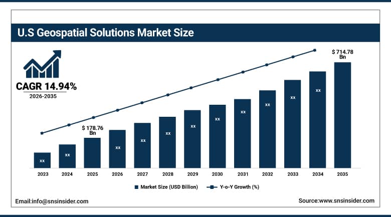
U.S. Geospatial Solutions Market was valued at USD 178.76 billion in 2025 and is expected to reach USD 714.78 billion by 2035, growing at a CAGR of 14.94% from 2026-2035.
The geospatial solution market in the United States is expanding owing to rising demands from the defense sector, urban planning and infrastructure development. The increasing usage of GIS, satellite imaging, location analytics, smart city projects, and government funding are propelling market growth.
The U.S. Department of Homeland Security's geospatial analytics spending for disaster response, border surveillance, and infrastructure monitoring exceeded USD 3 billion in 2023. USGS signed a partnership with NASA in February 2025 to launch a new satellite under the Landsat program to improve high-resolution geospatial image collection for environmental monitoring across agriculture, forestry, and climate applications.
Geospatial Solutions Market Segment Analysis
-
By Technology, GIS/Geospatial Analytics dominated the Geospatial Solutions Market in 2025; 3D Scanning fastest growing (CAGR).
-
By Component, Software dominated with ~45%+ share in 2025; Services growing fastest.
-
By Application, Surveying and Urban Planning dominated; Defense & Intelligence fastest growing.
By Technology, GIS/Geospatial Analytics dominates, 3D Scanning expected to grow fastest
The GIS/Spatial Analytics category ruled the Geospatial Solutions market in 2025, due to the rising demand for making informed decisions with the help of data. The increasing importance of managing resources efficiently and responding effectively to disasters has made GIS an essential part of spatial analytics. Integrating artificial intelligence into the GIS platform has enhanced the capability of spatial analytics beyond what was possible with conventional mapping systems.
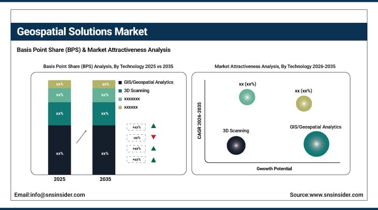
3D Scanning is expected to register the fastest technology CAGR from 2026 to 2035, driven by increasing applications in construction, manufacturing, heritage preservation, and urban digital twin development. The need for accurate and rich spatial data for 3D modeling and simulation is driving 3D scanning adoption across construction sites where it improves project planning and monitoring accuracy and in industrial facilities where as-built documentation and equipment inspection using 3D point cloud data are becoming standard practice.
Geospatial Solutions Market Regional Analysis
|
Region |
Major Country |
Share within Region (%) |
|---|---|---|
|
North America |
United States |
88% |
|
Europe |
Germany |
23% |
|
Asia Pacific |
China |
48% |
|
Middle East & Africa |
Saudi Arabia |
38% |
|
Latin America |
Brazil |
45% |
North America Geospatial Solutions Market Insights
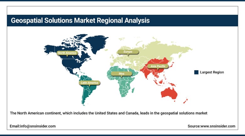
The North American continent, which includes the United States and Canada, leads in the geospatial solutions market because of the high level of technological infrastructural development and favorable government policies. The high deployment rate of GIS, satellite imagery, and locational analytics is fueling the market’s growth. The region is witnessing substantial investments in smart cities and autonomous cars. It has the presence of some big technology vendors as well as high real-time geospatial analytics usage.
Get Customized Report as Per Your Business Requirement - Enquiry Now
Europe Geospatial Solutions Market Insights
Europe, which includes Germany, France, and the UK, witnesses’ considerable growth due to regulations and sustainable development activities. Geospatial technologies have been utilized by governments in the region to monitor the environment, manage lands, and respond to any natural disaster situation. There is an emphasis on building smart infrastructure, precision agriculture, and climate change monitoring. Innovation through EU-funded projects and collaboration across borders will drive market growth.
Asia Pacific Geospatial Solutions Market Insights
Asia-Pacific is the fastest growing geospatial solutions regional market, fueled by the presence of an indigenous spatial data infrastructure in China through its Beidou satellite navigation system, an open policy framework in India for the use of technology in geospatial solutions that attracts substantial foreign investment, and fast-paced urbanization leading to a requirement for geospatial analysis of cities in the area. Investment from China for its geospatial solution infrastructure through the 14th Five-Year Plan in addition to the highest intensity of usage of geospatial data infrastructure for commercial purposes in agriculture, urban management, and defense, makes it the biggest regional market.
India's National Geospatial Policy 2022 liberalized geospatial data access for domestic private sector development. China's Ministry of Natural Resources reports that the BeiDou Navigation Satellite System now provides globally-available positioning data at accuracy levels comparable to GPS, providing China with independent geospatial data sovereignty for domestic applications.
Middle East & Africa and Latin America Geospatial Solutions Market Insights
Geospatial market opportunities are seen in regions such as the Middle East and Africa, Latin America, specifically Brazil, South Africa, and the United Arab Emirates, as these areas are becoming geospatial markets due to infrastructure developments and resource management. The governments are increasingly adopting GIS technology in their urban planning projects, mineral resources exploration, and environmental monitoring programs. Geospatial market growth can be attributed to significant investments in digitalization programs such as the smart city initiatives.
Geospatial Solutions Market Growth Drivers:
-
Government geospatial investment and AI-powered spatial analytics expansion creating transformative global geospatial solutions growth
The geospatial solutions market is benefiting from a virtuous cycle where government investment in geospatial data infrastructure creates the foundation for commercial value-added analytics services, which demonstrate the commercial value of spatial intelligence, which justifies further government investment. Government geospatial programs in the U.S., EU, China, India, and dozens of other national markets are collectively the largest single driver of both direct geospatial data platform investment and the commercial analytics ecosystem that processes and monetizes that data. AI's integration into geospatial platforms is simultaneously expanding what is possible automated change detection, predictive spatial modeling, natural language spatial querying and making it accessible to organizations without specialized GIS expertise, dramatically expanding the total addressable market beyond the government and specialized industry users who traditionally dominated geospatial analytics.
The World Bank's Digital Development Partnership has funded geospatial data infrastructure and analytics capacity building in over 60 developing countries since 2020. Gartner identifies geospatial analytics as one of the top 10 data and analytics technology trends with highest enterprise adoption momentum through 2027.
Geospatial Solutions Market Restraints:
High infrastructure costs and data privacy concerns limiting geospatial solutions adoption across smaller organizations globally
The cost of investing in geospatial infrastructure is enormous since the amount of money involved in the development and acquisition of software, hardware, and professional expertise makes it difficult for small to medium companies and developing nation governments with limited budgetary provisions in technological investments to fully adopt the geospatial infrastructure. Privacy of data, especially since geospatial data is extremely sensitive because it relates to the ability to trace an individual’s behavior by way of their location, implies the need for regulatory policies like GDPR and CCPA in commercial use of geospatial data analysis.
Geospatial Solutions Market Opportunities:
Location intelligence expansion and autonomous vehicle geospatial requirements creating vast new commercial opportunities globally
The commercial application of location intelligence combining organizational operational data with geospatial information to gain spatial understanding of customers, resources, and risks is expanding from specialist early adopters to mainstream enterprise adoption across retail, logistics, agriculture, real estate, and financial services. As more organizations recognize that understanding the spatial distribution of their customers, assets, and risks enables better decision-making than aspatial analytics alone, the enterprise market for geospatial solutions expands proportionally. Autonomous vehicle navigation represents a separate and large geospatial opportunity: self-driving vehicles require high-definition 3D mapping with centimeter-level accuracy that must be continuously updated as the physical environment changes a geospatial data product category with enormous commercial potential as autonomous vehicle deployment scales from pilots to production fleets.
Recent Developments:
-
2025: Esri released ArcGIS Pro 4.0 with native generative AI integration enabling natural language queries of spatial datasets, automated cartographic layout generation, and AI-assisted feature extraction from satellite imagery reducing the technical barrier for enterprise users to derive actionable spatial intelligence from complex multi-source geospatial datasets.
-
2025: Microsoft expanded its Azure Maps and Azure AI services for geospatial analytics, introducing new spatial AI capabilities enabling organizations to build location-aware applications with real-time data processing, predictive spatial modeling, and automated change detection from satellite and aerial imagery.
Geospatial Solutions Market Key Players
Some of the Geospatial Solutions Market Companies
-
Esri (Environmental Systems Research Institute)
-
Hexagon AB
-
Trimble Inc.
-
Maxar Technologies Inc.
-
Planet Labs PBC
-
HERE Technologies
-
Google LLC (Google Maps Platform)
-
Microsoft Corporation (Azure Maps)
-
Amazon Web Services (AWS Location Service)
-
Palantir Technologies Inc.
-
Airbus Defence & Space
-
Orbital Insight Inc.
-
SpaceKnow Inc.
-
Descartes Labs Inc.
-
Satellogic Inc.
-
Synthetaic Inc.
-
Picterra AG
-
CARTO
-
Bentley Systems Inc.
-
SafeGraph Inc.
Geospatial Solutions Market Report Scope
| Report Attributes | Details |
|---|---|
| Market Size in 2025 | USD 541.7 Billion |
| Market Size by 2035 | USD 2,166 Billion |
| CAGR | CAGR of 14.94% From 2026 to 2035 |
| Base Year | 2025 |
| Forecast Period | 2026-2035 |
| Historical Data | 2022-2024 |
| Report Scope & Coverage | Market Size, Segments Analysis, Competitive Landscape, Regional Analysis, DROC & SWOT Analysis, Forecast Outlook |
| Key Segments | • By Technology (GIS/Geospatial Analytics, Remote Sensing, GPS, 3D Scanning) • By Component (Software, Services, Hardware) • By Application (Urban Planning, Agriculture, Defense & Intelligence, Transportation, Others) |
| Regional Analysis/Coverage | North America (US, Canada), Europe (Germany, UK, France, Italy, Spain, Russia, Poland, Rest of Europe), Asia Pacific (China, India, Japan, South Korea, Australia, ASEAN Countries, Rest of Asia Pacific), Middle East & Africa (UAE, Saudi Arabia, Qatar, South Africa, Rest of Middle East & Africa), Latin America (Brazil, Argentina, Mexico, Colombia, Rest of Latin America). |
| Company Profiles | Esri (Environmental Systems Research Institute), Hexagon AB, Trimble Inc., Maxar Technologies Inc., Planet Labs PBC, HERE Technologies, Google LLC (Google Maps Platform), Microsoft Corporation (Azure Maps), Amazon Web Services (AWS Location Service), Palantir Technologies Inc., Airbus Defence & Space, Orbital Insight Inc., SpaceKnow Inc., Descartes Labs Inc., Satellogic Inc., Synthetaic Inc., Picterra AG, CARTO, Bentley Systems Inc., SafeGraph Inc. |
Frequently Asked Questions
Ans: North America dominated the Geospatial Solutions Market in 2025.
Ans: The 3D Scanning segment is expected to register the fastest CAGR through 2035.
Ans: The GIS/Geospatial Analytics segment dominated the Geospatial Solutions Market in 2025.
Ans: The Geospatial Solutions Market was valued at USD 541.7 billion in 2025.
Ans: The Geospatial Solutions Market is expected to grow at a CAGR of 14.94% from 2026 to 2035.
Get in Touch
