Remote Sensing Satellite Market Report Scope & Overview:
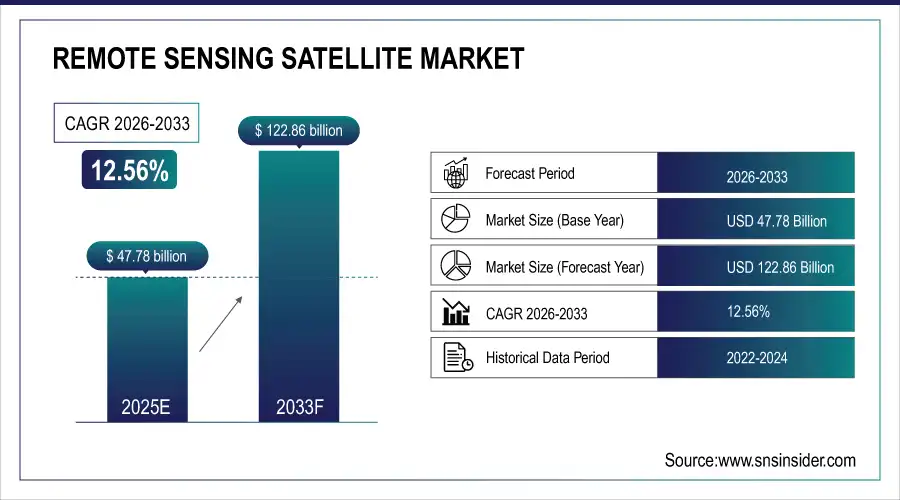
The Remote Sensing Satellite Market Size is valued at USD 47.78 Billion in 2025E and is projected to reach USD 122.86 Billion by 2033, growing at a CAGR of 12.56% during the forecast period 2026–2033.
The Remote Sensing Satellite Market analysis report is a precisely directed study offering detailed insights into the market. Space-based technologies have attracted substantial investment capital and are increasingly receiving government and commercial acceptance. Therefore, it is anticipated that the market will be a promising growth over the up-coming years.
Over 480 remote sensing satellites were launched in 2025, driven by rising investments and expanding commercial adoption.
Market Size and Forecast:
-
Market Size in 2025: USD 47.78 Billion
-
Market Size by 2033: USD 122.86 Billion
-
CAGR: 12.56% from 2026 to 2033
-
Base Year: 2025
-
Forecast Period: 2026–2033
-
Historical Data: 2022–2024
To Get more information On Remote Sensing Satellite Market - Request Free Sample Report
Remote Sensing Satellite Market Trends:
-
An increase in the use of compact, low-cost small satellites is transforming the remote sensing approach on the ground.
-
AI and machine learning are increasingly used to analyze satellite pictures, increasing data precision and information.
-
Public–private collaborations have broadened, including satellite launch ventures, resulting in increased levels of invention.
-
Expansion of the commercial solutions industry for more efficiently accessible high-resolution image processing.
-
Technological development on reusable launch vehicles has lowered deployment costs, allowing satellite deployments to be made more frequently.
-
Existence of cloud-based analytical platforms that incorporate satellite information has accelerated the transmission process.
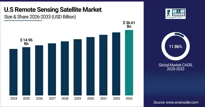
U.S. Remote Sensing Satellite Market Insights:
The U.S. Remote Sensing Satellite Market is projected to grow from USD 14.96 Billion in 2025E to USD 36.61 Billion by 2033, at a CAGR of 11.86%. Growing investments toward defense surveillance, Earth observation programs expanding private sector participation in advanced satellite imaging technologies.
Remote Sensing Satellite Market Growth Drivers:
-
Growing demand for high-resolution Earth observation data supporting climate monitoring, defense intelligence, and resource management.
Growing demand for high-resolution Earth observation data is a key driver of the Remote Sensing Satellite Market growth. Satellite imagery plays an important role for governments, defense agencies, and private enterprises in environmental monitoring, urban planning, and security operations. Other applications include agriculture, disaster management, and resource mapping. As imaging technologies and analytical tools improve and provide increasingly timely data to decision-makers, these markets will continue to increase across sectors and geographies.
High-resolution Earth observation data demand grew over 15% in 2025, driven by expanding climate monitoring programs and increased defense surveillance needs.
Remote Sensing Satellite Market Restraints:
-
High satellite manufacturing and launch costs, coupled with complex regulatory approvals, are constraining market expansion globally.
High satellite manufacturing and launch costs, along with complex regulatory approvals, present major restraints for the Remote Sensing Satellite Market. The high capital-intensive of satellite development restricts entry to only large corporations and government agencies. The lengthy approval processes and compliance with space laws are time-consuming and further delay project completion timelines. The high risk of launch failure and maintenance costs are a continued threat to profitability and market are limitations to scalability. The barriers dissuade new entrants especially smaller organizations.
Remote Sensing Satellite Market Opportunities:
-
Rising integration of AI-driven analytics and cloud platforms presents vast opportunities for innovation in satellite data services.
Rising integration of AI-driven analytics and cloud platforms presents a major opportunity for the Remote Sensing Satellite Market. Utilizing these technologies allow for faster and more accurate interpretation of vast datasets captured by satellites and promotes appropriate decision-making in various industries such as agriculture, defense, environmental monitoring. In addition, cloud-based solutions make the data more accessible for other users in real time and encourage cooperation between all concerned parties. AI and cloud technology are the key to superior offerings, new revenue sources, and industry change for companies.
AI-powered satellite data solutions made up 22% of new launches in 2025, driven by rising demand for real-time analytics.
Remote Sensing Satellite Market Segmentation Analysis:
-
By Satellite Type, Optical Imaging held the largest market share of 46.27% in 2025, while Hyperspectral satellites are expected to grow at the fastest CAGR of 14.63% during 2026–2033.
-
By Orbit, Low Earth Orbit (LEO) dominated with a 57.84% share in 2025, while Medium Earth Orbit (MEO) is projected to expand at the fastest CAGR of 12.48% during the forecast period.
-
By Application, Earth Observation accounted for the highest market share of 39.52% in 2025, while Environmental Monitoring is anticipated to record the fastest CAGR of 13.27% through 2026–2033.
-
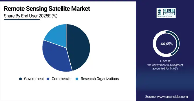
By End User, the Government segment held the largest share of 44.65% in 2025, while the Commercial segment is expected to grow at the fastest CAGR of 15.36% during 2026–2033.
By Satellite Type, Optical Imaging Dominates While Hyperspectral Expands Rapidly:
Optical Imaging segment dominated the market owing to the extensive use of this imaging in high-resolution Earth observation and mapping. Optical satellites are used largely by governments and private players for urban planning, agriculture, and defense imaging. Hyperspectral is the fastest-growing segment, powered by increased demand for precision data in mineral exploration and environmental analysis. In 2025, over 220 optical imaging satellites were operational, underscoring its leadership.
By Orbit, Low Earth Orbit (LEO) Dominates While Medium Earth Orbit (MEO) Expands Rapidly:
Low Earth Orbit (LEO) segment dominated the market due to its ability to drive fast data transmission, low-latency rates, and cheaper satellite launch investments. Since the LEO is closer to the planet, it provides clear enough quality of imaging to shuffle it daily. Medium Earth Orbit (MEO) is the fastest growing segment as the applied navigation and communication develop. In 2025, more than 300 satellites were operating in LEO, driving data connectivity and observation networks.
By Application, Earth Observation Dominates While Environmental Monitoring Expands Rapidly:
Earth Observation segment dominated the market as it reflects the highest demand for geospatial data used in agriculture, infrastructure, and defense planning. It is also considered the cornerstone of the satellite origin. Environmental Monitoring is the fastest-growing segment as the industry is under increased attention due to climate changes, deforestation monitoring, and natural cataclysms forecasting. Over 180 Earth observation missions were active in 2025, showcasing its pivotal market role.
By End User, Government Dominates While Commercial Expands Rapidly:
Government segment dominated the market as a result of substantial investment in defense surveillance, border security, and national infrastructure monitoring. Public agencies have continued to finance substantial satellite programs for strategic and environmental reasons. Commercial is the fastest growing segment owing to the growing role of the private industry in data analytics, resource mapping, and precision agriculture. In 2025, over 65 government-led satellites were launched globally, highlighting the segment’s continued dominance in the industry.
Remote Sensing Satellite Market Regional Analysis:
North America Remote Sensing Satellite Market Insights:
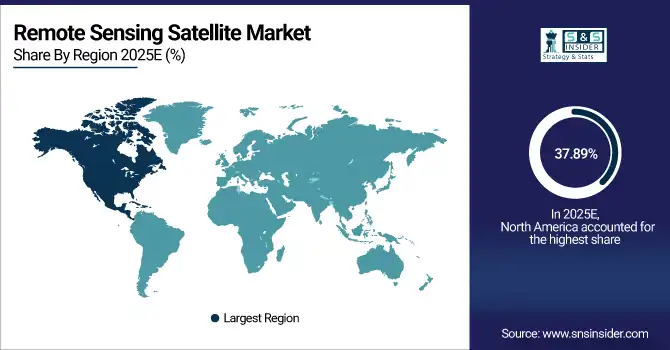
The North America Remote Sensing Satellite Market dominates the world landscape with a 37.89% market share in 2025. Governmental investments in strong defense, space exploration, and climate monitoring programs, especially from the likes of NASA and the U.S. Department of Defense, have continued to be increased. The overall commercial satellite ecosystem of the region, its technological infrastructure, and ever-growing cooperation between private space companies and various federal agencies continue to prove that North America leads the way with its satellite-based remote sensing capacities.
Get Customized Report as per Your Business Requirement - Enquiry Now
U.S. Remote Sensing Satellite Market Insights:
The U.S. Remote Sensing Satellite Market is propelled by robust government funding, faster commercialization of satellite data services and technological breakthroughs. The market is being transformed due to the rising use of remote sensing satellites in defense, environmental monitoring and intelligent infrastructure. The collaboration of private aerospace firms with state agencies further propels innovation and improves the country’s space capability.
Asia-Pacific Remote Sensing Satellite Market Insights:
The Asia-Pacific Remote Sensing Satellite Market is the fastest-growing region, projected to expand at a CAGR of 15.44% during 2026–2033. The growth is powered by increasing investments in space programs in China, India, and Japan and rapidly growing demand for satellite-based Earth observation and environmental monitoring. The growing commercial satellite launches, government cooperation and technological advances are increasing data access, making Asia-Pacific a vibrant powerhouse of the remote sensing market.
China Remote Sensing Satellite Market Insights:
The China Remote Sensing Satellite Market is fueled by strong government space missions, rising commercial satellite companies, and evolved picture and video technologies. Increasing investments in Earth observation, environmental monitoring, and defense settlement observation are boosting growth. Their management in launch ability and data performance strengthens their regional dominance in the Asia-Pacific satellite environment.
Europe Remote Sensing Satellite Market Insights:
Europe is a highly lucrative market in the remote sensing satellite industry due to space technology, environmental monitoring, and defense demand. France, Germany, and the U.K. are key European nations heavily invested in the industry, conducting co-missions and launching next-generation observatory satellites with the European Space Agency. European interest in high-resolution imaging, extensive climate data study, and the growing role of commercial service providers will further solidify the region as a dominant industry market.
France Remote Sensing Satellite Market Insights:
France maintains its strong presence in the Remote Sensing Satellite Market. With highly advanced aerospace capabilities and strong governmental backing, France leads Europe’s satellite space, due to progressive Earth observation programs via CNES and ESA. French innovation in the field of aerial imaging and data analytics further consolidates the country’s position on Europe’s satellite map.
Latin America Remote Sensing Satellite Market Insights:
The Latin America Remote Sensing Satellite Market is gaining momentum, driven by growing investments in satellite technology and regional space programs in Brazil, Mexico, and Argentina. Moreover, growing applications in agriculture, disaster management, and environmental monitoring and partnerships with international space agencies, will propel the region’s technological development and market expansion.
Middle East and Africa Remote Sensing Satellite Market Insights:
The Middle East & Africa Remote Sensing Satellite Market is expanding with the increasing investments in space technology, defense modernization, and environmental monitoring. The UAE, Saudi Arabia, and South Africa are driving developments with national satellite programs and regional collaboration and data-driven programs to support sustainable developments and security improvement.
Remote Sensing Satellite Market Competitive Landscape:
Airbus Defence and Space, headquartered in Leiden, Netherlands, is a leader in aerospace innovation and satellite technology. The Remote Sensing Satellite Market is led by the company utilizing its advanced Pleiades, SPOT, and TerraSAR-X constellations which deliver unmatched imaging accuracy and reliability. Furthermore, Airbus uses its engineering experience of several decades to offer integrated geospatial and navigation solutions for defense, agriculture, and environmental monitoring. Its constant technological innovation push, data service and numerous alliances with the leading space agencies ensure Airbus’s overwhelming leadership.
-
In January 2025, Airbus launched the SpainSat NG-I satellite on a Falcon 9. Built on the Eurostar Neo platform, it enhances secure communications with adaptive antenna technology and tenfold capacity, reinforcing Europe’s strategic satellite dominance.
Maxar Technologies, based in Westminster, Colorado, is a powerhouse in the Remote Sensing Satellite Market, known for its ultra-high-resolution Earth imagery and geospatial intelligence services. Maxar uses the world-renowned WorldView and GeoEye satellite series to provide and develop imaging solutions in defense, intelligence, and commercial sectors. This company’s particular strengths are an advanced AIO analytics and near-real-time image processing and data accuracy. With constantly improving satellite capabilities and cloud-based delivery platforms, Maxar will keep be among the leaders of shaping and developing remote sensing.
-
In February 2025, Maxar launched its fifth and sixth WorldView Legion satellites, expanding its high-resolution Earth-imaging constellation. The upgrade strengthens revisit frequency, data accuracy and coverage for defense, environmental monitoring, and commercial intelligence applications.
Lockheed Martin Corporation, headquartered in Bethesda, Maryland, is one of the world’s most influential aerospace and defense companies. This company is a dominant force in the Remote Sensing Satellite Market. It designs and develops advanced satellites for Earth observation, weather forecasting, and defense applications. Lockheed’s technological excellence, long-established partnerships with NASA and U.S. defense agencies, and specialization in small satellite and sensor technologies characterize its leading position. Lockheed’s dedication to precision, reliability, and innovation makes its market dominance in space-based intelligence and surveillance solutions evident.
-
In May 2025, Lockheed Martin launched the GPS III SV08 satellite from Cape Canaveral. This latest addition boosts positioning accuracy, resilience, and interoperability, marking continued leadership in next-generation navigation and defense-grade satellite infrastructure.
Remote Sensing Satellite Market Key Players:
Some of the Remote Sensing Satellite Market Companies are:
-
Airbus Defence and Space
-
Maxar Technologies
-
Lockheed Martin Corporation
-
Northrop Grumman Corporation
-
Thales Group
-
Boeing Defense, Space & Security
-
L3Harris Technologies
-
OHB SE
-
Planet Labs Inc.
-
BlackSky Global LLC
-
ICEYE
-
Capella Space
-
Satellite Imaging Corporation
-
GeoSense
-
Antrix Corporation
-
Ball Aerospace & Technologies Corp.
-
Mitsubishi Electric Corporation
-
Hexagon AB
-
Surrey Satellite Technology Limited (SSTL)
-
UrtheCast Corp
| Report Attributes | Details |
|---|---|
| Market Size in 2025E | USD 47.78 Billion |
| Market Size by 2033 | USD 122.86 Billion |
| CAGR | CAGR of 12.56% From 2026 to 2033 |
| Base Year | 2025E |
| Forecast Period | 2026-2033 |
| Historical Data | 2022-2024 |
| Report Scope & Coverage | Market Size, Segments Analysis, Competitive Landscape, Regional Analysis, DROC & SWOT Analysis, Forecast Outlook |
| Key Segments | • By Satellite Type (Optical Imaging, Radar Imaging, Hyperspectral, Others) • By Orbit (Low Earth Orbit (LEO), Medium Earth Orbit (MEO), Geostationary Orbit (GEO)) • By Application (Earth Observation, Environmental Monitoring, Agriculture, Disaster Management, Defense & Intelligence, Mapping & Navigation, Others) • By End User (Commercial, Government, Research Organizations) |
| Regional Analysis/Coverage | North America (US, Canada), Europe (Germany, UK, France, Italy, Spain, Russia, Poland, Rest of Europe), Asia Pacific (China, India, Japan, South Korea, Australia, ASEAN Countries, Rest of Asia Pacific), Middle East & Africa (UAE, Saudi Arabia, Qatar, South Africa, Rest of Middle East & Africa), Latin America (Brazil, Argentina, Mexico, Colombia, Rest of Latin America). |
| Company Profiles | Airbus Defence and Space, Maxar Technologies, Lockheed Martin Corporation, Northrop Grumman Corporation, Thales Group, Boeing Defense Space & Security, L3Harris Technologies, OHB SE, Planet Labs Inc., BlackSky Global LLC, ICEYE, Capella Space, Satellite Imaging Corporation, GeoSense, Antrix Corporation, Ball Aerospace & Technologies Corp., Mitsubishi Electric Corporation, Hexagon AB, Surrey Satellite Technology Limited (SSTL), UrtheCast Corp. |
Get in Touch
