
Drone Analytics Market Report Scope & Overview:
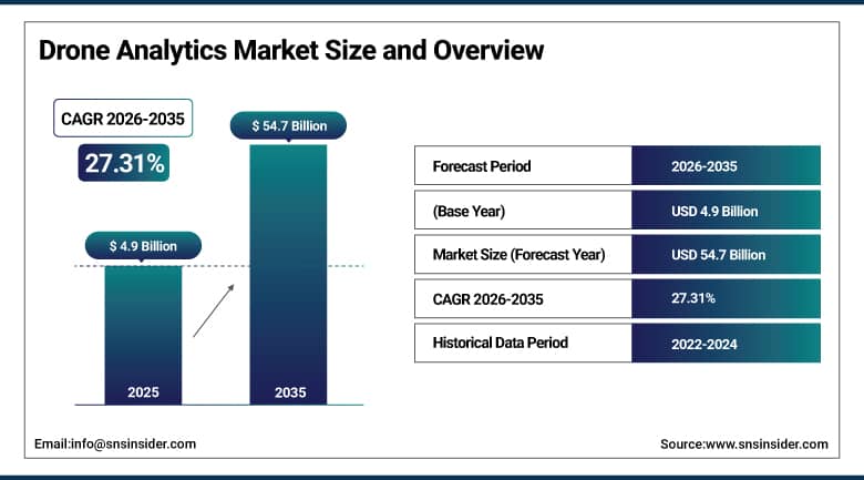
Drone Analytics Market was valued at USD 4.9 billion in 2025 and is expected to reach USD 54.7 billion by 2035, growing at a CAGR of 27.31% from 2026-2035.
The Drone Analytics Market is experiencing rapid growth due to the increasing adoption of drones for applications such as infrastructure inspection, precision agriculture, construction monitoring, mining, and energy assets management. Companies are turning to artificial intelligence-driven drone analytics, live aerial imagery, and cloud-based computing technologies to enhance efficiency and minimize costs associated with inspections. The drive towards building smart cities and automation is another important factor adding to the growth of the market.
The FAA's 2024 Aerospace Forecast projects that commercial drone operations in the U.S. will exceed 900,000 annual authorizations by 2025, with industrial inspection, precision agriculture, and surveying as the three largest commercial drone use categories by flight hours.
DJI Enterprise reports that energy sector clients using its drone inspection platforms with AI analytics have reduced infrastructure inspection costs by 40-60% relative to equivalent human inspection programs, representing the ROI case that is driving utility and energy company drone analytics adoption globally.
To Get More Information On Drone Analytics Market - Request Free Sample Report
Drone Analytics Market Trends
-
Rising adoption of drones for aerial data collection and real-time monitoring is driving the drone analytics market.
-
Growing demand across agriculture, construction, mining, energy, and defense sectors is boosting market growth.
-
Expansion of AI-powered image processing and geospatial analytics is fueling deployment.
-
Increasing focus on predictive insights, operational efficiency, and asset inspection is shaping adoption trends.
-
Advancements in machine learning, cloud computing, and high-resolution imaging technologies are enhancing analytics accuracy and scalability.
-
Rising investments in autonomous drone operations and smart infrastructure monitoring are supporting market expansion.
-
Collaborations between drone manufacturers, analytics software providers, and enterprise users are accelerating innovation and global adoption.
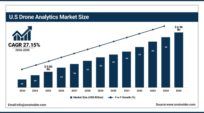
U.S. Drone Analytics Market was valued at USD 0.80 billion in 2023 and is expected to reach USD 6.96 billion by 2032, growing at a CAGR of 27.15% from 2026-2035.
US Drone Analytics Market is experiencing high growth because of increasing use of drones in various industries like construction, agriculture, military, logistics, and energy for the purpose of real-time monitoring and predictive analytics. The combination of Artificial Intelligence, machine learning, and cloud computing is improving efficiency while cutting down cost of inspections. Favorable government policies, increasing use of commercial drones, and increased investments in smart infrastructures have also fueled the growth of this market.
The American Society of Civil Engineers' 2021 Infrastructure Report Card which gave U.S. infrastructure a C- overall identified over 45,000 structurally deficient bridges, 45,000 miles of highways in poor condition, and thousands of dams and levees requiring inspection creating a massive infrastructure monitoring need that drone analytics is uniquely positioned to address at the inspection frequency and spatial resolution that human inspection programs cannot economically sustain.
Drone Analytics Market Segment Analysis
-
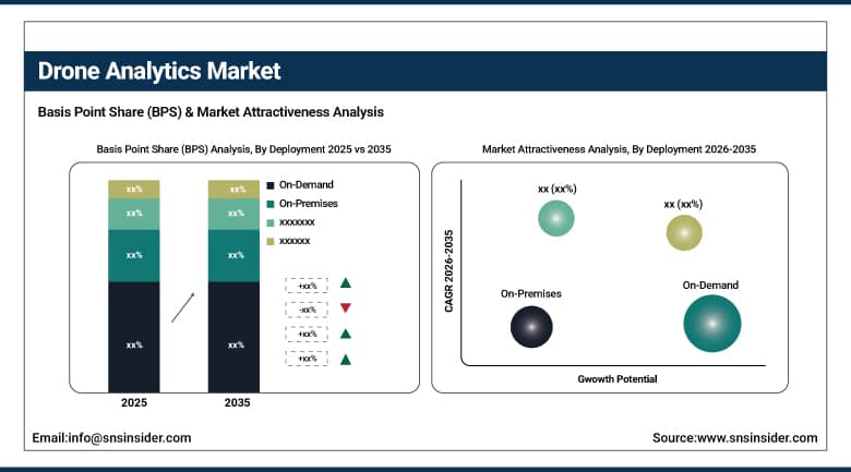
By Deployment, On-Premises dominated with ~65% share in 2025; On-Demand growing fastest at ~28.48% CAGR.
-
By Solution, End-to-End Solutions dominated with ~66% share in 2025; Point Solutions growing fastest at ~28.93% CAGR.
-
By End Use, Power & Utility dominated with ~30% share in 2025; Construction & Infrastructure growing fastest at ~29.50% CAGR.
-
By Application, Thermal Detection dominated with ~35% share in 2025; 3D Modeling growing fastest at ~29.09% CAGR.
By Deployment, On-Premises deployment dominates the Market, On-Demand expected to grow fastest
The On-Premise Deployment Model is the dominant in the Drone Analytics Market due to its high data security, control, and capability to accommodate mission critical applications in defense, utilities, and infrastructure monitoring industries. Enterprises working with aerial intelligence information have preferred the deployment model since it provides better protection against cybersecurity threats and compliance issues. The model supports custom integration with the existing enterprise system while providing large-scale analytics capabilities.
On-demand is witnessing rapid growth due to its scalability, reduced initial costs, and remote access capabilities. Companies now have a preference towards Cloud-based Deployment Models because of the ease of data processing and real-time collaboration and software upgrades. Increasing adoption of AI-based Analytics, rise in the use of drones for commercial applications, and increasing demand for scalable storage facilities fuel this trend. Small and Medium sized enterprises in particular prefer cloud deployment for analytics.
By Solution, End-to-End Solutions segment dominates the Market, Point Solutions segment expected to grow fastest.
End-to-end solutions segment leads the Drone Analytics Market, driven by the tendency of organizations to use integrated systems that unite several aspects of data gathering, analysis, visualization, and reporting in one ecosystem. It allows optimizing the process of managing a drone fleet, ensuring better internal effectiveness, and reducing dependence on third-party suppliers. Enterprises that operate in energy, agriculture, mining, and infrastructure industries are able to reap great benefits from the centralized system with automated processes and forecasts, making decisions based on collected information. Thus, providing comprehensive information boosts the demand for end-to-end solutions within drone analytics.
Point solutions are witnessing rapid growth because of the increasing need for specialized analytics solutions tailored to meet certain needs within an industry, like thermographic imaging, mapping, assets tracking, or predictive maintenance. Modular solutions are gaining more favor in order to be more flexible and not make excessive investments into developing holistic solutions. Breakthroughs made in artificial intelligence, machine learning, and computer vision are providing considerable help in developing niche analytics solutions. Customized analytics solutions for drones have become one of the significant factors driving the market for point solutions.
By End Use, Power & Utility segment dominates the Market, Construction & Infrastructure segment expected to grow fastest.
The utility and power segment is the leading segment within the Drone Analytics Market as there is an increasing requirement for drones for inspection purposes, such as transmission line inspection, grid monitoring, vegetation assessment, and infrastructure maintenance. By implementing drone analytics, utilities can ensure increased safety, decreased inspection time, and lower maintenance costs through fault identification at the time of occurrence. Smart grids and renewable energy infrastructure modernizations are boosting the demand for drone analytics. Predictive maintenance also adds to utilities' benefits.
The construction and infrastructure segment is the fast-growing end-use segment, which has witnessed growing utilization of drones in project surveying, construction progress, three-dimensional modeling, and project monitoring. The use of drones for analytics provides more accurate projects, compliances with safety measures, and lower manual inspection time on-site. Increased investments in smart cities, transportation systems, and infrastructure construction have contributed to the growth of the market.
By Application, Thermal Detection segment dominates the Market, 3D Modeling segment expected to grow fastest.
The Drone Analytics Market is dominated by the thermal detection segment, which is efficient in monitoring machines, structures, and the environment across different industries such as utilities, oil and gas, military, and agriculture. Thermal drones help detect any irregularities in the heat signature, machine problems, energy losses, and security hazards precisely. Besides, thermal analysis has been useful in low visibility and disaster situations, prompting its use in different industrial applications.
The fastest-growing segment within the Drone Analytics Market is 3D modeling, driven by the rising requirement for spatial visualization, digital mapping, and infrastructure planning. Various industries, including construction, mining, real estate, and urban development, utilize drones' 3D models to enhance design precision, project monitoring, and resource optimization. With technological improvements in photogrammetry, LiDAR sensors, and artificial intelligence-driven rendering solutions, 3D modeling accuracy and processing speed have improved significantly.
Drone Analytics Market Regional Analysis
|
Region |
Major Country |
Share within Region (%) |
|---|---|---|
|
North America |
United States |
88% |
|
Europe |
United Kingdom |
27% |
|
Asia Pacific |
China |
40% |
|
Middle East & Africa |
UAE |
35% |
|
Latin America |
Brazil |
48% |
North America Drone Analytics Market Insights
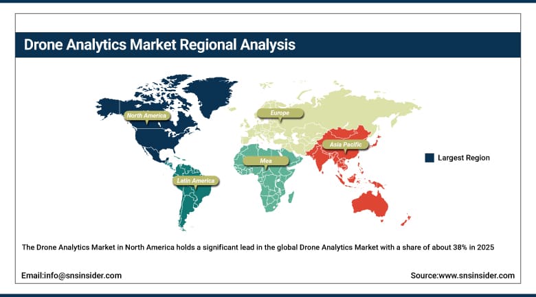
The Drone Analytics Market in North America holds a significant lead in the global Drone Analytics Market with a share of about 38% in 2025. This is attributed to the high rate of adoption of advanced drones technology, investments made in the provision of solutions for data analytics, and application in various sectors including defense, agriculture, construction, and energy. Other contributing factors include fast-paced innovation, favorable regulatory environments, and involvement of large industry players. The ongoing integration of artificial intelligence (AI) and machine learning into the processing of drone data further boosts the market performance.
Get Customized Report as Per Your Business Requirement - Enquiry Now
Asia Pacific Drone Analytics Market Insights
The Asia Pacific region is the fastest-growing regional Drone Analytics Market due to quick digitalization, growth in industrial automation, and usage of drones in agriculture, construction, logistics, and smart cities. Investment in AI-based analytics solutions, favorable government policies, and higher demand for real-time data analysis are contributing to the expansion of the market. The region is seeing significant usage of drone technology for surveillance and mapping purposes. Besides, cost-effective production and startup growth are also playing a critical role in promoting the development and deployment of drone analytics solutions in the Asia Pacific region.
India's drone sector policy liberalization including the Drone Rules 2021 and PLI scheme for drone manufacturing is stimulating domestic commercial drone adoption whose analytics requirements create growing market demand.
Europe Drone Analytics Market Insights
The Europe Drone Analytics Market has been growing steadily due to the rising use of drones in applications such as infrastructure inspection, agriculture, energy, and environmental monitoring. The presence of strong regulations concerning drone safety and the development of AI-based analytics and geospatial data processing systems is contributing to the effectiveness of the market. Additionally, the Europe region is seeing high levels of investment in smart cities and automation. The increasing need for precision agriculture and renewable energy monitoring is also fueling the adoption rate.
MEA and Latin America Drone Analytics Market Insights
MEA Drone Analytics Market is experiencing healthy growth due to increased investment in smart cities, oil and gas surveillance, and infrastructural development. Drone technology is increasingly used by governments to conduct surveillance operations and map natural resources. In Latin America, market growth is being boosted by advancements in agricultural technologies, mining activities, and developments in digital infrastructure. The use of AI-based analytics and cloud computing platforms is being increased in both MEA and LATAM markets to increase efficiency. Shortage of technical knowledge and expensive implementations are major hurdles faced by the market.
Drone Analytics Market Growth Drivers:
-
Increasing Adoption of AI-Powered Aerial Intelligence Platforms Across Construction, Agriculture, Energy, Mining, and Infrastructure Inspection Operations Worldwide
Increased requirement for real-time aerial intelligence and automatic operation monitoring is fueling the growth of adoption of drone analytics platforms in several industries around the world. Drone analytics software is increasingly being used by businesses to perform asset inspections, streamline business processes, minimize downtime and boost decision making. In the construction and infrastructure sector, drone analytics platforms are employed in order to perform site mapping, project progression monitoring and risk management. Precision farming analytics software, on the other hand, is used in the agriculture sector to maximize agricultural yield and efficiency. Energy and utility providers are also employing drone analytics to monitor their pipeline networks and renewable energy installations.
Drone Analytics Market Restraints:
-
Complex Aviation Regulations and Airspace Restrictions Limiting Commercial Drone Deployment Across Several High-Potential Industrial and Urban Applications Globally
Strict laws and policy measures related to airspace management are an additional obstacle in the widespread deployment of drone-based analytics software systems in diverse geographic regions. The enforcement of such laws and policies imposes restrictions on flight clearance, altitude ceiling, pilots' credentials, and flying beyond visual line of sight. Changes in policies and delayed approval processing create uncertainty and complicate the execution of projects. Privacy invasion and cyber attacks associated with air surveillance deter corporations and governmental institutions. Legal and regulatory problems impede the process of integration and deployment, particularly in congested metropolitan cities and highly regulated sectors.
Drone Analytics Market Opportunities:
-
Expanding Integration of 5G Connectivity and Edge Computing Enabling Real-Time Drone Data Processing and Autonomous Analytics Capabilities Worldwide
The fast deployment of 5G technology and edge computing is presenting major possibilities for the use of cutting-edge drone analytics platforms in the coming years. Through the provision of rapid connectivity, drones will be able to send massive amounts of high-definition aerial images instantly in real-time, thus making the decision-making process more efficient and accurate. Edge computing provides drone analytics platforms with the capability to analyze data from close proximity at the actual point of operation. Some key benefits of technological innovation include the ability to facilitate autonomous drone operations, AI-powered analysis, predictive maintenance, and instant anomaly detection.
Recent Developments:
-
2026: Skydio launched its Skydio X10D defense-grade drone with integrated AI analytics onboard, enabling real-time defect classification during flight identifying transmission line corona discharge, insulator contamination, and structural anomalies at 60 frames per second with 95.3% detection accuracy in FAA-authorized evaluation missions eliminating the post-flight data processing step that previously added 4-24 hours between drone inspection mission completion and actionable maintenance recommendation delivery.
-
2025: DroneDeploy expanded its enterprise platform with automated change detection algorithms comparing sequential drone survey datasets to identify ground movement, vegetation encroachment, and structural changes in utility infrastructure corridors with Pacific Gas & Electric's California transmission network as the launch partner for a program covering 18,000 miles of transmission line using 200 drones operating simultaneously in coordinated automated survey missions.
-
2025: Trimble acquired e-Drone Technology's precision agriculture analytics division, integrating multispectral imagery processing, crop stress quantification, and prescription map generation directly into Trimble's Ag software ecosystem enabling seamless data flow from drone flight through analytics to variable-rate application equipment prescription without the manual data export/import steps that previously disconnected drone analytics from precision agriculture execution workflows.
Drone Analytics Market Key Players
Some of the Drone Analytics Market Companies
-
AgEagle
-
Skydio
-
DroneDeploy
-
Kespry
-
Insitu
-
Parrot
-
AeroVironment
-
ESRI
-
Draganfly
-
PrecisionHawk
-
Viatechnik
-
Pix4D
-
HUVRdata
-
DJI
-
3D Robotics
-
Sentera
-
Agribotix
-
Airware
-
Delta Drone
-
Optelos
| Report Attributes | Details |
|---|---|
| Market Size in 2025 | USD 4.9 Billion |
| Market Size by 2035 | USD 54.7 Billion |
| CAGR | CAGR of 27.31% From 2026 to 2035 |
| Base Year | 2025 |
| Forecast Period | 2026-2035 |
| Historical Data | 2022-2024 |
| Report Scope & Coverage | Market Size, Segments Analysis, Competitive Landscape, Regional Analysis, DROC & SWOT Analysis, Forecast Outlook |
| Key Segments | • By Deployment (On-Premises, On-Demand) • By Solution (End-to-End Solutions, Point Solutions) • By End Use (Power & Utility, Construction & Infrastructure, Oil & Gas, Agriculture, Transportation & Logistics, Others) • By Application (Thermal Detection, Aerial Monitoring, Ground Exploration, 3D Modelling, Others) |
| Regional Analysis/Coverage | North America (US, Canada), Europe (Germany, UK, France, Italy, Spain, Russia, Poland, Rest of Europe), Asia Pacific (China, India, Japan, South Korea, Australia, ASEAN Countries, Rest of Asia Pacific), Middle East & Africa (UAE, Saudi Arabia, Qatar, South Africa, Rest of Middle East & Africa), Latin America (Brazil, Argentina, Mexico, Colombia, Rest of Latin America). |
| Company Profiles | AgEagle, Skydio, DroneDeploy, Kespry, Insitu, Parrot, AeroVironment, ESRI, Draganfly, PrecisionHawk, Viatechnik, Pix4D, HUVRdata, DJI, 3D Robotics, Sentera, Agribotix, Airware, Delta Drone, Optelos |
Frequently Asked Questions
Ans: North America dominated; Asia Pacific is the fastest growing regional market.
Ans: Power & Utility dominated with approximately 30% share; Construction & Infrastructure is fastest growing at 29.50% CAGR.
Ans: On-Premises dominated with approximately 65% share; On-Demand is fastest growing at 28.48% CAGR.
Ans: The Drone Analytics Market was valued at USD 4.9 billion in 2025.
Ans: The Drone Analytics Market is expected to grow at a CAGR of 27.31% from 2026 to 2035.
